
© Martin Rose
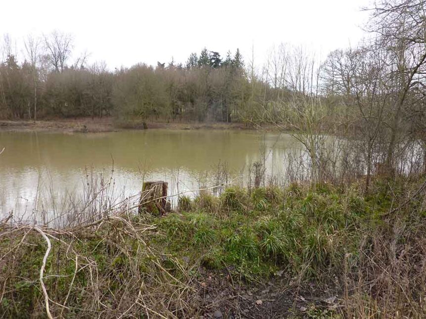
Featured image above – The Fishmere, January 2021, © Martyn Everett
This article (with added 2026 updates & amendments) was first published in Saffron Walden Historical Journal No. 41 Spring 2021
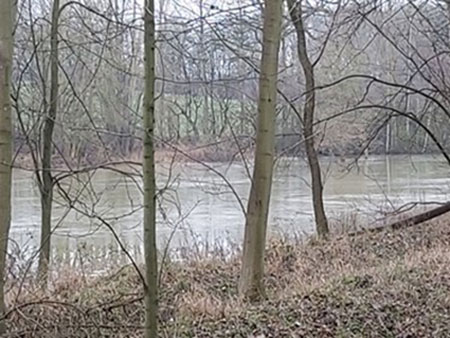
If you walked along Chestnut Avenue towards the Old Cambridge Road last winter, you’ll have had a surprise: a large lake, seen through the trees to the south where you probably don’t remember seeing a large lake before. It is an interesting stretch of water, on the one hand created, or at least encouraged, very recently; and on the other the assertive ghost of a vanished mere that probably goes back thousands of years.
Since the Neolithic, five or six thousand years ago, the Cam valley has been settled and exploited. It lies beneath the modest chalk uplands to the west, a spur of the Chilterns, and the water ran, as it still does, off the upper slopes along seasonal stream-beds down to the Cam. More water moves below the surface through gravel-filled conduits (‘lenses’) between chalk and clay and comes to the surface in springs at about the 200-foot line. Below that, the water once pooled on the gravel beds on the floor of the valley, around the confluences with the Cam. In early times, wrote George Morris, ‘the valley bottoms were choked with a swamp or wet alder wood flora and there are indications that at Newport, Wenden and Saffron Walden the side valleys below the spring heads were occupied by either incipient fens or shallow lakes’. We know these stretches of shallow water in much later historical memory as Newport Pond, Wicken Water and the Fulfen, or ‘Fowl Fen’. Where the run-off from the Catmere End and Littlebury Green valley, joined by the lesser flow from Chapel Green, came down to the Cam valley floor, a water known as the Fishmere spread out, a fenny lake permanent enough, judging by its name, to sustain a population of fish. It was located in the depression to the south of Chestnut Avenue and the west of the old Cambridge Road – and this is where we saw standing water this winter. At times it must have extended further down to and across the river.
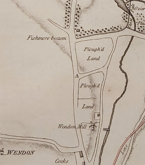
The Fishmere persisted through the Middle Ages and probably longer. The field that today slopes down from Chestnut Avenue to the water was known two centuries ago (and perhaps more recently) as Fishmore Bottom (originally, presumably, Fishmere Bottom), so marked on maps like the canal survey of 1788 (fig 1) and Chapman & André’s Essex map of 1777 (fig 2). It was fertile land and its name suggests that it was reclaimed from the mere, part of a shrinkage over time as the edges were drained. In the eighteenth century a different process, of digging clay for brick-making, opened up pits close to the lowest point of the depression, which must by then have been more or less dry. At some point, in the late eighteenth or early nineteenth century a drainage ditch was made which still carries the run-off from the valley through the culvert under Chestnut Avenue by the railway embankment. It cuts diagonally across Fishmore Bottom and was ‘perched’ – it was in other words raised and separated from the lake-edge with an impermeable bank. In the first place this was presumably to drain the fen; and then to keep the valley’s winter rainfall out of the clay-pit. It by-passed the lake (and diggings) entirely, running between the lake and the road and then under the road opposite the entrance to London Lodge.
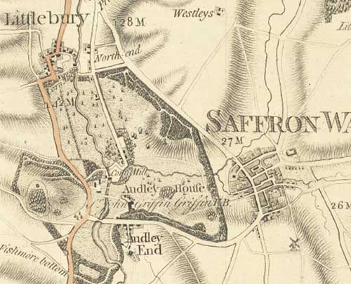
Quite when the balance shifted from draining the remains of the mere to protecting the clay-diggings is not clear: it may be that the last stage of reclamation was a by-product of the clay-pits. Digging for clay there began in the 1760s and continued intermittently into the twentieth century, with its apogee in the 1840s. On the 25-inch Ordnance Survey map of 1897 (fig 3) there is still a fairly respectable lake filling the clay-diggings, coloured blue to confirm that the diggings were at least seasonally flooded; but in the last century it shrank considerably, and the 1985 (2½” map) shows only a small puddle.
The lake must always have grown in winter and shrunk in summer, but in the last couple of years, this has been positively encouraged. The perched drainage ditch (visible on nineteenth-century maps ) has been allowed to breach so that its water once again enters the lake. As Audley End’s Resident Agent, Tom White, explains, ‘the water has broken though now, with a bit of encouragement, to help the flooding. It won’t get any deeper, as it overflows back into the ditch downstream’. And he goes on, ‘an ambition of our gamekeeper and me, decades in gestation, led a couple of years ago to clearing some of the poor poplar trees (planted for the match industry which declined years ago) in this area and we spent a day or two with a digger clearing it out a little and scraping one or two low spots as a refuge for water-living creatures when the rest dries out’.
The water has found a new winter equilibrium and it may well have beneficial effects in allowing the lake once again to absorb and retain floodwater. This year has seen heavy rain up in Littlebury Green and Catmere End, most of which drains ultimately into the lake. Quite how heavy, is shown by rolling rainfall averages (recorded at Wendens Ambo) for the twelve months to the end of January 2019, 2020 and 2021: they are 478mm, 582mm and 799mm respectively – an increase of 67% in the last three years. Rainfall across the Anglian region over the whole of 2020 was 192% of the 1981-2010 average.
The well in lower Strethall was measured in September last year when the water level was found to be more than four feet below the road surface: by mid-January it had risen to pool in the road above the well-grating. All the ponds along the ridge are full, and in late winter all the drainage ditches are running fast and full, too.
*
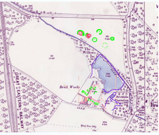
All this extra rainfall has contributed to the lovely new waterscape at the bottom of the valley. What we are looking at here, then, is not just a lake, but the site of an early industrial zone on the Audley End estate. The poplars were planted for manufacturing phosphorus matches; but the staple activity for well over a century was brick-making, using the clay from the ancient lake-bed: the ruins behind the poplar woods are still known as ‘the Brickyard’. Its outline is clear on successive maps of the area, first in 1876/77, when the clay-pit and the pug-mill are easily discernible along with the making-house and two long drying-sheds. There appear to be two square kilns and there is little obvious sign of mechanisation. By 1896 the buildings have shrunk a little and there is only one drying-shed. The site is still labelled ‘Brickworks’, as it is again, more or less unchanged, in 1919. An assessment made by Historic England in 2010 included an aerial survey which is used for the overlay map in fig. 3: it shows much the same layout.
When the Eastern Counties Railway line was built across the estate in 1844-45, Lord Braybrooke extracted very comfortable terms for the land-purchase, and major concessions for the route: between Wendens Ambo and Littlebury, where it crossed his estate, the line was set back beyond the lip of the valley, invisible from Audley End. To do so, it went over the tallest viaduct (at 70 feet) in the county, at Wenden, and through the only two tunnels on the London-Cambridge line. Each of these elements required very large numbers of bricks: in the case of the two tunnels, perhaps nine million. But the 1844 Act of Parliament which authorised the line north of Newport (a private act much of which was of course drafted for, and approved by, Lord Braybrooke) was very restrictive in all sorts of ways. One of them was a complete ban on clay-digging and brick-making anywhere on the Audley End estate.
It would be easy to assume that this ban was imposed because Lord Braybrooke did not want his view from the mansion, or his sweet air, sullied with industrial pollution. But in fact he already had brick-kilns on his estate: Richard Ward, master brick-maker and bricklayer to Sir John Griffin Griffin in the rebuilding of Audley End (1762-97), built two kilns, one of which was in the angle of Chestnut Avenue and the Old Cambridge Road, in the woods called ‘Brickyard Plantation’ a very few yards to the east of Lord Braybrooke’s brickyard. (The other was at Claypits on the Debden Road: the two kilns were built in 1763 and 1772.) Braybrooke, in other words, already had brick-making capacity on the estate, and suddenly a ready-made demand materialised on his doorstep: in 1844 the capacity at the Brickyard was presumably expanded considerably and the double-chambered kilns started to fire continuously, sending their bricks up the line the short distance to the bricklayers who worked a few feet behind the tunnelling gangs, building the brick tunnel-sleeve.
The 1840s were a time of rapid change in the brick-making industry. Mechanisation was slowed by the brick tax which was not abolished until 1850, but the one area in which it advanced rapidly in the 1840s was in the making of railway bricks. As Edward Dobson writes, ‘A contractor who requires say 10,000,000 of bricks, to be made in a limited time, for the construction of a tunnel or viaduct, can employ machinery with great advantage …. The two most used in this country are Ainslie’s and Hunt’s’. It seems likely that Braybrooke’s works were at least partially mechanised. Dobson goes on, ‘as the whole process of railway brickmaking often occupies but a few weeks from the first turning over of the clay to the laying of the bricks in the work, the use of rollers is very desirable, as a partial substitute for weathering’. Bricks were made fast, and often crudely. ‘[Railway] contractors are generally little anxious as to the shape or appearance of the article turned out of the kiln, provided it be sufficiently sound to pass the scrutiny of the inspector or resident engineer.’
There was another brickworks, off Rookery Lane in Wendens Ambo: it was right at the foot of the viaduct and County archæologists have concluded that it was fired in 1844-45 and not thereafter. Its ownership is not clear, but the land on which it stood may have passed from the estate of John Robinson to Lord Braybrooke soon after Robinson’s death in 1841. If so, Braybrooke was making virtually all of the bricks for the railway crossing his estate, from the Wenden viaduct to Chesterford. The clauses in the Act banning brick-making were not, therefore, to protect the estate, but to protect Lord Braybrooke’s profitable monopoly on supply to the tunnels on which he had insisted – and whose stone portals were covered in his family’s florid heraldic devices.
Using brick prices from comparable contemporary tunnels, Lord Braybrooke was probably paid about £22,000 for his bricks (and a good deal more if he also provided the bricks for the viaduct). Whatever his profit margin, it was a useful addition to the £38,000 clear he made from selling land to the ECR.
*
The argument comes full circle, from bricks back to lakes, because clay pits are one of the commoner precursors of ponds. The clay deposited in the Fishmere over millennia was good brick-clay; and the pit from which it was dug filled with water when that source of clay was abandoned, beginning the recreation of the mere. The survey made of the area by Historic England shows a large area of excavation exactly where the mere lies today. The Fishmere seems to be an autopoietic system – one that struggles constantly to regain and retain its original form; and we are very fortunate to see it grow, albeit not to quite the full expanse of fen and water that it once was. Or as Tom White puts it: ‘it is always a surprise to see how quickly nature takes the lead, especially if you lend a helping hand’.
Illustrations
Fig 1 The Canal Map 1788, detail, Essex Record Office
Fig 2 Ordnance Survey Map, 25” 1897, detail, National Library of Scotland CC-BY-NC-SA
Fig 3 Overlay of Historic England survey onto Ordnance Survey Map; overlay © Historic England Archive; map National Library of Scotland CC-BY-NC-SA
Fig 4 The Fishmere, January 2021, photograph Martin Rose
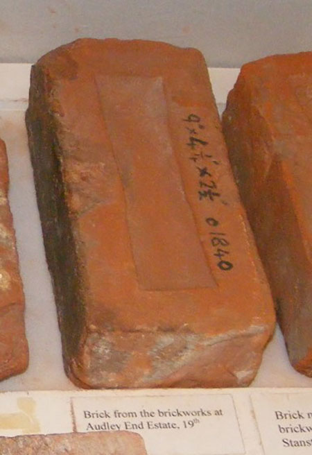
Fig. 5 Brick from the brickworks at Audley End Estate
References
Alexander, Magnus et al, Audley End: Historic Landscape Investigations (Research Report no. 46-2011): English Heritage, 2015
Ball, Geoffrey: Richard Ward, Bricklayer at Audley End, Saffron Walden Historical Journal, no. 30, Autumn 2015
Coxall, Simon: Chapter 1 in Wendens Ambo, A History of an Essex Village, ed. Robert Wilson, Wendens Ambo, 2019
Dobson, Edward, A Rudimentary Treatise of the Manufacture of Bricks and Tiles, London: John Weale, 1850
Hesse, Mary: The Anglo-Saxon Bounds of Littlebury, Proceedings of the Cambridge Antiquarian Society LXXXIII, pp 129-39
Historic England, aerial survey of the Audley End estate. The CAD file is © Historic England Archive and is referenced MD002678. It is the combined Air Photo and Lidar transcription for the Audley End survey, produced in April 2010.
Letch, A R: Historic Building Record of a Brick Kiln at ‘The Rookery,’ Rookery Lane, Wendens Ambo, Essex, Essex County Council Field Archæology Unit, July 2004.
Morris, George: Some Neolithic Sites in the Upper Valley of the Essex Cam, Essex Naturalist, vol 20 part ii, April-September 1922
National Hydrological Monitoring Programme, Hydrological Summary for the United Kingdom (monthly), December 2020.
Newman, Ken: The distribution and origin of ponds in Essex with special reference to the parish of Broomfield, Transactions of the Essex Society for Archæology and History, vol 4 (fourth series), 2013
Ordnance Survey, 6” Maps of Essex, 1876, 1897 and 1919.
Ryan, Pat: Brick in Essex: The Clayworking Craftsmen and Gazetteer of Sites, Colchester: Pat Ryan, 1999
Simms, F W and Haskoll, W D: Practical Tunnelling, London: Lockwood, 1860
With thanks to Martyn Everett for photographs and reminiscences; to Joe Platts for meteorology; to Simon Coxall for invaluable advice; to Michael Sutherill for wisdom on bricks; to Tom Williamson for reading; and to Tom White for explaining the work he has been doing on ‘the Brickyard’ in the last couple of years.