

© Sarah Kirkpatrick
First Published in Saffron Walden Historical Journal No. 26 Autumn 2013 (with recent additions)
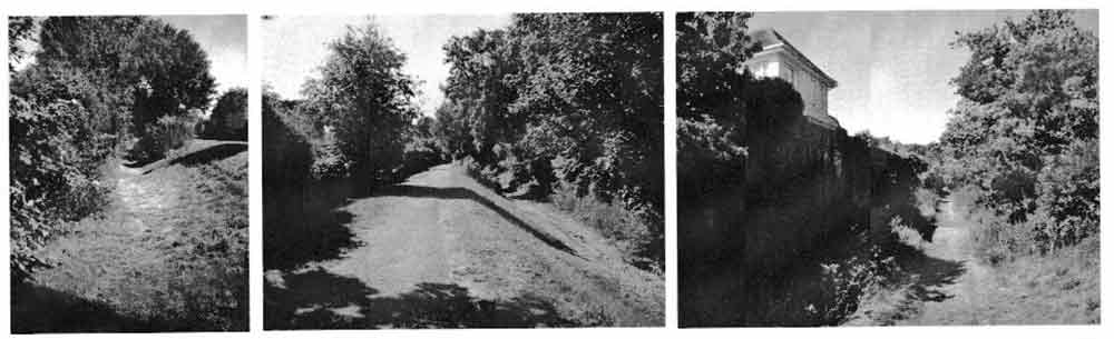
The above is an up to date image of the lower ditch looking south. © Saffron Walden Historical Society.
In 2012, I became involved with the filming of Saffron Walden for the ‘Town’ BBC Television series with Nicholas Crane. By a quirk of fate I got to speak on the programme about an area of the town that is never included in any of the guided tours of the town that I have taken over the last 19 years – the earthworks commonly known as the Battle Ditches. In preparing for filming I read as much as I could and indeed read as much after filming. This article brings together some of that reading and offers some suggestions as to the purpose of the Battle Ditches and a possible candidate for the driving force behind such a large undertaking. It should be said that the earthworks are most probably part of the town enclosure, but throughout the article they will be called the Battle Ditches.
Lord Braybrooke, is always my first point of reference and he writes:
On the west and south sides of the town is an extensive range of stupendous earthworks, known by the name of the Battle or Peddle Ditches…… they commence in the Abbey Lane….. running for a considerable distance in a straight line to the west ward, suddenly taking a southerly direction and terminate near the entrance to the town from the London Road. The length of the southern bank is 702 feet and of the western 480….. the west bank, formally extended to a wet ditch at the end of the almshouses meadow…. of the other bank, some vestiges are to be observed much further southwards and it was perhaps originally carried round that side of town.1
Lord Braybrooke, writing in The History of Audley End (1836)
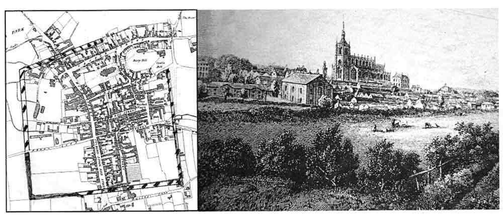
Lord Braybrooke also notes that the ditches were called Pell, Repell, Bestle and Paigle Ditches by other writers. He was also of the opinion that they were nothing to do with the castle defences ‘much higher antiquity’ The map above is from Braybrooke’s history (Figure 1), and the Town Library also has an old etching which shows the Battle Ditches in the early 19th century Figure 2).
Mr Guy Maynard, an early 20th century Saffron Walden historian and curator of the Museum, seemed to have been indefatigable in looking down any ‘hole’ that was ever dug during his tenure and noticing many features. Particularly in the case of the Battle Ditches, he noted the digging of the town sewers in 1911 along Fairycroft Road, thus establishing the eastern extent of the Battle Ditches. It was not until much later in the 20th Century, that the first modern archaeological excavations of the Battle Ditches took place – indeed, the only one across the remaining section. For three weeks in July 1959, a team led by Mrs Alison Ravetz and Miss Gillian Chapman dug across the western arm of the Battle Ditches 2. In a tradition carried on during the the summer of 2013 in the ‘Dig on the Common’ they had students from a local school, in their case, the Friends’ School and volunteers from the WEA (Workers’ Education Association) to help. They found in 1959 that the length of the west ditch was 484 feet from Abbey Lane going south, and 495 feet from the turn going towards the London Road. The latter can be seen to have lost 207 feet in length since recorded by Lord Braybrooke in 1836, while the former is very similar in length. At that time, Ditches were, and still are, a Scheduled Ancient Monument so permission from the Ministry of Works was needed, as well as permission from the then owner, the 9th Lord Braybrooke in order to carry out the excavation.
The area through which the Battle Ditches were dug, was already known to be the site of the Romano/Saxon/Norman settlement, first discovered with the unearthing of skeletons in the 1830s and Saxon burial ground in 1876. The number of burials found in the 1830s may have resulted in the naming of the ditches ‘Battle Ditches’ in the mistaken belief that all the bodies were buried at the same time as a result of a battle, rather than over a greater length of time.
The quantity of pottery found in the 1959 excavation suggests that occupation of the area was relatively intense between 1050-1150, but tailed off from about 1150-1200, and was very much less by the early 1200s. This range of pottery confirms our understanding of the development of the town. The building of the Castle between 1125 and 1140 resulted in the gradual shift of the centre of the town away from the village in the valley to the top of the hill around the new Castle. The original settlement declined over 60-70 years and the construction of the Battle Ditches through the old village effectively put this area on the edge of the village and there it remained, sparsely developed until the 1930s when the first houses appeared on the Gibson estate.
As well as the excavation reports, maps and other documentation were looked at. One of the features which was noted, was the existence on the 1758 map of the town, of a shallow pond just to the east of the current end of the Ditch near London Road. This may have been the end of the Ditch before it stopped at the High Street, which in 1836 was still called Cucking Stool End Street. Was this perhaps the Ducking Stool Pond for scolds and argumentative people, created from a part of the Battle Ditches? The pond had been filled in by 1836.
Documentary survivals are rare for this period, as all the Court Rolls were lost in the 1381 Peasants Revolt, but there are some surviving early documents relating to land-holding in Saffron Walden in which the Battle Ditches are mentioned. The first reference we have to a ‘magnum fossatum‘ (great ditch) is in 1304 when it was a land boundary. Ditches were often used as land boundary markers – examples of this are: in 1331, a ‘magnum fossatum domini comitus Hereford (great ditch of the lord earl of Hereford) mentioned in another land charter, and a ‘parvum fossatum Roberti de Aschenden‘ (the small ditch of Robert of Arkesden).
With the evidence available at the time of the 1959 dig, the conclusion was reached that the Battle Ditches enclosed land only on the southern half of the town, that is south of the Abbey Lane and Hill Street axis, but certainly extending from the existing Battle Ditches across the top of Gold Street, and as far east as Fairycroft Road and down to where it meets East Street.
Developments within the town in the 1970s gave many opportunities for new archaeological discoveries. The work carried out in this decade was brought together by S.R Bassett in the large volume Saffron Walden Excavations and Research 1972-80, and this work still forms the basis of our understanding of the development of the early medieval town of Walden.3
The re-development of the old cinema maltings site on the corner of Gold Street and the High Street was excavated in 1972-3, when archaeologists found the projected line of the Battle Ditches.4 There is a good photograph in H.C. Stacey’s Saffron Walden in Old Photographs showing the excavation in progress.5 Today if you walk down the High Street from the war memorial, count three trees down and turn towards the current buildings, you are standing in the line of the battle ditches. If you turn and look across the High Street towards Margaret Way, you are looking at the site of the Ducking Stool pond.
It was not until excavations at the back of the Rose & Crown in July 1972, on what had been their bowling green and is now car park, that the line of the eastern arm of the Battle Ditches was found.6 This was the first time that evidence that the Battle Ditches extended north towards the Castle was discovered. Bassett also re-considers the pottery found in the 1959 dig beneath the bank of the Battle Ditches, and suggests that the two shards are pre-1250, not post-1250.7
In 1975, the local government offices in Abbey Lane were in a bad state of repair and Hanover Housing Association were given permission to develop the land. However, before they did so, because of the importance of the site, in the blistering heat of July and August 1976, Mr M.R. Petchy led an archaeological excavation. The continuation of the Battle Ditches north of Abbey Lane had already been remarked on by Lord Braybrooke as a ‘wet ditch’, and evidence of the edge of the Battle Ditch was certainly found, as was extensive evidence of the 10th-12th Century settlement.
S.R. Bassett’s dating of the ditches to 1236 includes them as part of a town plan involving moving the market from its position near the Church and Castle (the current churchyard between the Church and the High Street) down to its current position in the Market Square and rebuilding the Church. This new town plan was also thought to be tied up with a charter that was thought to be granted in 1236, although that date was disproved by Dr Jennifer Ward and the charter re-dated to 1300.8 Bassett also proposed a rectilinear street plan of the town as part of the new town plan.
Work done in the early 1980s before redevelopment of sites in the Slade valley where the swimming pool had been (now the site of Janet Riley Fabrics), led to some questioning of the sequence of events that Bassett set out. Since the excavators found evidence of human habitation outside the outer bailey for a date before the Battle Ditches were dug, they put forward the theory that the Battle Ditches were contemporary with the building of the Castle and the inner and outer baileys i.e. 1140s not 1230s.9
Dr. Maria Medlycott, in her Saffron Walden town assessment report, stays with Bassett’s theory and also mentions that the Battle Ditches were found under Swan Meadow car park, and possibly continuing through the water meadow opposite Freshwell Gardens, before turning towards the outer bailey ditch to the north of Castle Street. 10 The latest discoveries about the Battle Ditches were written up in 2011, after the re-development of the yard at the back of 63 Castle Street offered an opportunity for a small-scale dig in 2005.
The ditch excavated at 63A Castle Street is clearly part of the outer bailey defences of the 12th century Castle and lies directly on the previously postulated line… dating evidence suggests that the original outer bailey ditch may already have been partially filled when it was incorporated in the new town enclosure in the 13th century. 11
says Trevor Ennis
In looking for candidates for the instigator of the task of digging an earthwork consisting of a ditch and bank, with the ditch being about 20 feet wide from lip to lip, 7-9 feet deep and extending roughly two miles (2020m) in total, we have to look to the Lord of the Manor. The question is which Humphrey de Bohun, as there were three successive lords of that name from 1236 onwards. Some time in the late 1190s Maud de Mandeville married Humphrey de Bohun, who owned vast estates in the Welsh marches. De Bohun was made Earl of Hereford in 1200 by King John, just about the time de Bohun’s eldest son was born. The 1st Earl of Hereford fell out with King John in about 1212, and was one of the 25 Barons appointed after the signing of the Magna Carta in 1215 to see that the terms of the charter were kept. The 1st Earl of Hereford died on pilgrimage to the Holy Land in 1220 and never held Walden Manor. That year was doubly unhappy for Maud, Countess of Hereford, as her elder brother Geoffrey de Mandeville, Earl of Essex, was killed in a tournament outside London, leaving his younger brother William to become Earl of Essex. But when he died seven years later in 1227, Maud inherited the Mandeville lands in her own right as a widow, and for the next nine years was Countess of Essex, as well as Dowager Countess of Hereford. On her death in 1236, Walden had its first de Bohun Lord of the Manor.
Humphrey de Bohun (1200-1275), second carl of Hereford, inherited from his father vast lands mainly in the Welsh Marches, Wiltshire. He gained more land from his first wife, Matilda Luisignan in Kent. He inherited the Mandeville lands from his mother when he was 36. He must be the main candidate for the building of the Battle Ditches – that is if they were built somewhere between 1236 and 1275, as seems likely. Three possible reasons present themselves for consideration for probable motives for such a vast undertaking as digging the Battle Ditches. As would any new owner, De Bohun may have seen new possibilities and encountered old problems. The town was growing out of its confines of the outer bailey ditches, and the area for the market was constrained between the road and the Church, leaving no room for expansion. By moving the market down to its present position, it was able to expand and a larger Church could be constructed in the former market area. The oldest part of the present Church dates to the 1230s. Access to the new market place needed both to be controlled and protected by a new town enclosure. The placing of the western edge of the Battle Ditches brings us to a consideration of the problems with Walden Abbey. Land disputes tend to rumble on. De Bohun’s grandfather, Geoffrey Fitz Peter’s quarrel in the 1190s led to violent confrontation between a Reeve and the monks as well:
Those sons of darkness ranged though the fields (and) with impudent hands they pulled up the boundary marks which had been deep in the ground to signify the boundaries of our land and carried them off so that the bounds and extents which tod originally been assigned to us were utterly confused.12
It is a little more difficult to fill in a large ditch and the Battle Ditches nearest to the Abbey lands certainly stood the test of time. The placing of this western arm of the Battle Ditches also finally destroyed any last vestiges of the Saxon and early Norman village, and left the site as fields and latterly gardens for 700 years.
The reign of Henry III (1216-1272) was rife with baronial disputes and a place of safety in a town enclosure was certainly an asset for any town. De Bohun’s lands were vast, and leaving Walden with a new town plan, a new church and the Battle Ditches, seems the least he could do for the chief manor of the lands he inherited from his mother, the last De Mandeville heiress.
Using the accumulation of modern archaeological evidence, it is possible to plot the line of the 13th century Battle Ditches, or more properly the town enclosure. The current orthodoxy is that the Battle Ditches were part of a new town plan of the 1230s with a possible 1236 date. The documentary evidence certainly gives us a date before 1304 and also the owner of The Great Ditch in 1331, the Earl of Hereford, although realistically there was no one else but the lord of the manor with the power and authority to instigate such a large project.
Today the Battle Ditches form a pleasant walkway between Abbey Lane and Gibson Gardens, much enjoyed by townsfolk (Figures, 3, 4, 5)
References
1. Braybrooke, Lord, The History of Audley End (1836), p. 148.
2. Ravetz & Spenser, Excavations of the Battle Ditches (1959), in Transactions of Essex Archaeological Society (1962), pp 141 159
3 Bassett S.R., Saffron Walden Excavations and Research 1972-1980 (1982)
4. Bassett, op.cit., pp 71-74
5. Stacey, H.C., Saffron Walden in Old Photographs (1980), Plate 146.
6. Bassett, op cit., pp 67-70.
7. Bassett, op.cit
8 Ward, J, The De Bohun Charter of Saffron Walden (1986), p.3
9. Andrews D., Mundy C & Walker H., Recent Archaeology in Saffron Walden Town Centre, Saffron Walden Historical Journal No 7 (Spring 2004), pp 3-6 extract from full report in Essex Archaeology & History Vol 33 (2002), pp 221-273
10. Medlycott M., Saffron Walden Historic Towns Project Assessment (1999), pp 5, 15.
11 Ennis T. ‘Investigations on the Medieval Defences of Walden Castle, Saffron Walden 2005-9 in Essex Archaeology & History Vol 2 (2011), pp. 98-106.
12. Greenway D. & Watkiss L. (eds. & trans.), The Book of the Foundation of Walden Monastery (1999), p. 135.
See also
White, M., Saffron Walden’s History, a chronological compilation (1991)
Oxford Dictionary of National Biography (Online)
Note: Sarah Kirkpatrick, who has lived in Saffron Walden for 19 years but grew up in Clavering, is a member of the Blue Badge Guides and was interviewed by Nicholas Crane on the BBC Town programme in which she discussed the history of the Battle Ditches. See article below (p.18 of the Journal):
‘Town’ BBC TV Programme
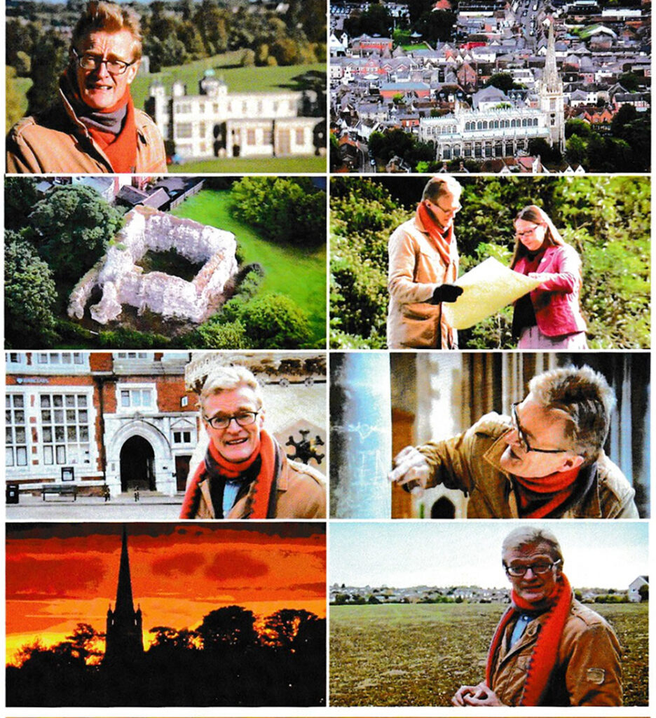
An hour-long documentary programme devoted to Saffron Walden was screened on BBC on 28 May 2013. Hosted by Nicholas Crane, it centred very largely on the town’s history showing how change had impacted on Walden over the centuries – and wondering how it would fare against the new challenge of huge development proposals. Interspersed with stunning aerial views of the town, Nicholas Crane visited various places including St Mary’s Church, the Market Place and the allotments – here he met David Smale cultivating saffron, the crop which made the town famous. At Audley End, he interviewed Amanda Murray, eldest daughter of Lord Braybrooke, who explained how the eight daughters of the family cannot inherit the estate. He tried out the craft of pargetting with Bill Sargent, and sampled wines on sale at the railway station shop, and the beer produced by a new brewery company. Councillors, an estate agent, campaigners and skatepark members all gave their views about new housing. His meeting with Blue Badge Guide, Sarah Kirkpatrick about the Battle Ditches is discussed in this issue (see article above). The presenter described Saffron Walden as ‘unusually intoxicating, seductive, incredibly alluring’, but concluded that, as in many other parts of the country, it was facing ‘a new Battle of Britain’ over housing plans. The photographs above (screen shots, hence poor quality) show, clockwise from top left: Audley End, aerial shot of the town and church, talking to Sarah Kirkpatrick about the Battle Ditches, examining graffiti in the parish church, looking at the fields near Thaxted Road subject to the largest planning proposal, sunset over the town, the Market Place and an aerial view of Walden Castle.